We have been people of the Grand River for just over two hundred years now but there are a few problems with our situation. The problem with these problems is that they are nearly invisible.
The biggest one is that according to the Indian Act we don’t actually own Six Nations Reserve No. 40 because Canada considers these 50,000 acres to be Federally owned Crown Land.
There is an illusion of ownership and control but most people are able to recognize that certain rules and regulations apply to this land when it comes to commerce and trade that are not defined by our government but by corporate Canada.
According to our own history and law there are two views. One is that we were awarded this land because of our allegiance to the British during the Revolutionary War as chronicled by the Haldimand Proclamation.
The other view is that Ontario and the Grand River did not belong to anyone because it was the Beaver Hunting Grounds therefore the Huron or the Mississaugas broke a pre-existing treaty (Dish with One Spoon) by selling common-law land to a fledgling Province of Canada 300 years ago. This view asks, “What right did Haldimand have to award us our own land, our hunting grounds?” If we follow this legacy then Ontario is not a province it is a giant refrigerator for the indigenous people of the northwest of the continent.
At this time we are in diaspora. The word diaspora refers to a scattered population with a common origin in a smaller geographic area. The word can also refer to the movement of the population from its original homeland.
The next invisible problem is that our nations have taken on a secondary identity as a refugee within a foreign authority and land. We are the Six Nations of the Grand River, the Mohawks of the Bay of Quinte and the Oneida of the Thames. Does anyone remember that we used to be the League of Nations of the Finger Lakes?
Even our names in the language reflect our true homelands, Kanienkehaka means people of the place of the flint, Onondaga means people of the rolling hills etc. etc. How long will it be until we change our name to people of the Grand River, or people of the flat clay soil? Maybe people of the crappy area the British didn’t want?
When I look at the Israel-Palestinian conflict the biggest thing I see is that it took the Jews 1878 years to return home after Titus crushed Jerusalem in 70 A.D. They were dispersed northward, and like the Haudenosaunee they lived in exile amongst other nations as second rate citizens for hundreds of years.
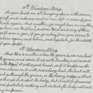
The successor state of Canada has not been acknowledging our pre-existing treaties with their Monarch. We aren’t getting the best treatment or recognition as allies. Instead we are governed as subjects because our population was annihilated by diseases that we had no immunity to. How long will we endure until we give them their three warnings? How long until we splash red onto the wampum?
As far as we know we have never broken the Two Row Wampum or the Covenant Chain, we are always trying to polish it. Why is that? Is it even possible for us to declare these treaties null and void due to gross negligence by the British party?
Regardless of how that situation works out, can we envision a day when we gather our people together and retake our original homeland back? Do you know that the Haudenosaunee people today have a total population of over 300,000? If we have 500,000 people by 2020 is that enough for us to march the 300 km or so back to our ancestral lands? Or do we have to wait until there are a million of us in the year 2050?
Until then we will continue to endure hardship and turmoil as a displaced people within a system that dishonors us and our legacy. Until then our hearts will groan in anticipation to be revealed to the world who we truly are and who we have always been.


Thanks for your input Cory! I’ve seen the ancient leather maps that Leeroy brought out from the vaults of the Hodiyaneso showing most of the north east as Haudenosaunee territory which is our area of influence but Dutch explorers circa early 1600’s journaled the NY State area as Mohawk and Oneida country. We didn’t think of hard borders the way the europeans did but our area of influence was always in motion like the northern lights the way I understand it.
Archaeology along the shores of St Lawrence, Lakes Ontario & Erie show a heavy Rotinosoni presence in Southern Ontario for over 1000 years – Mohawk to the east, Cayuga Port Hope to Kingston and Seneca in the west.
In 1990 a Cayuga village was discovered in the Kawarthas around Apsley. It is also well know that all the rivers that flowed south were Rotinosoni Territory and all the rivers flowing north to the Ottawa River were Algonquin.
Check out the MItchell Map 1757. It provides a clear picture of North America pre-proclamation period. You’ll need to zoom in for the details and comments around the Great Lakes.
http://www.davidrumsey.com/luna/servlet/detail/RUMSEY~8~1~222~20037:A-Map-of-the-British-and-French-Dom
Please pardon my ignorance, I am here to learn. What exactly does the term Rotinosoni mean, and who does it refer to? How does it differ from Haudenosaunee?
Actually the facts:
● The Grand River Settlement area was Rotinosoni territory since at least 700AD. However, stories suggest Southern Ontario from both lakes north 50 miles was Rotinosoni territory long before that.
● The Huron are not the Wendat. Huron was a term coined by the French to describe people living north of the St Lawrence River, Lake Ontario and Lake Erie. Iroquois was the term created to describe the people living south of the St. Lawrence River, Lake Ontario & Lake Erie.
● Southwestern Ontario was not the Beaver Hunting Grounds. That actual territory was located in the Michigan Peninsula , not Ontario.
● Land identified under the Nanfan Treaty of 1701 did not include any land north of a line drawn between Detroit & Hamilton.
● By 1656 all land in Southern Ontario, south of the Ottawa River to Nippissing was under the control of Rotinosoni & recognized as “Six Nations Territory”.
● The One Spoon One Bowl treaty invited the Mississauga from North of Superior into Southern Ontario to share the land. This was done primarily to limit the harrassment of hunters Rotinosoni experienced from lingering Wendat settled in the Beaver Hunting Grounds west of Detroit. The Mitchell Map 1757 identifies the Mississauga north of Lake Superior as the 8th member of the Confederacy.
● The meeting at Burlington between the Mississauga & Haldimand in 1783 was not a land surrender. According to the Court rules to identify a bonafide surrender, it lacks all required components.
● The meeting at Burlington in 1783 was brokered by Rotinosoni Chiefs to only obtain compensation for the Mississauga that had settled in the area under the One Spoon One Bowl treaty.
● The Royal Proclamation 1763 was not a treaty nor did it (does it) contain confirmation of Rotinosoni rights. Like the Haldimand Proclamation 1784, it was a directive to the British colonists & settlers that “Indian” lands (all of southern Ontario as well as all lands west of the Mississippi River were off limits to them for any reason, use or purpose, under the threat of penealty for treason.
● The Royal Proclamation 1763 was prescribed as a result of Rotinosoni Chiefs, acting as brokers for other nations refusing further land surrenders or settlments west of the Allegheny River. Refusal under the negotiation during the Treaty of Logstown 1752 to abide by the warning would result in war on the “frontier” & torching of farms & settlements in prohibited lands.
● Since 1752 Six Nations has never surrendered any more land. There have been false documents, lies & trickery used by the British & settlers to try to show that there have been surrendered but the covenant in 1752 has remained intact. However, both the penalties under the Royal Proclamation & the Haldimand proclamation for unlawful, treasonist settlement of Rotinosoni lands has been ignored bythe British and the Canadian government.
● Today, Southern Ontario south of the Ottawa River to Nippissing under law remains the territory of Six nations. As such, all settlers in the framed area are subject to Rotinosoni laws and benefits. They should not be charged tax by the government or harrassed as guests of the Rotinosoni, nor can they interfere with any Rotinosoni people in the use and enjoyment of their territory.
The Five (later Six) Nations Iroquois surrendered a huge tract of land including land in the what is now the U.S.A and land in what is now southwestern Ontario and along the Grand River to the British Crown and “for ever quit claime” to that land according to .Albany (Nanfan) Treaty in 1701.
New York surveyor Samuel Clowes (sometimes spelled Clows) made a map of the Nanfan Treaty area at the meeting when the treaty was signed in 1701 and he signed the treaty. That map is held in the British Archives. It shows the Nanfan Treaty land included land in southwestern Ontario from Windsor to around Parry Sound and south on a diagonal to around Burlington.
A copy of that Clowes (Clows) map of the 1701 Nanfan Treaty area was brought forward and used In the 2003, R. v. Barberstock court case,
Hello Six Nations!
Readers will find this map pertinent to the above Editorial…
http://www.firstnationsseeker.ca/Level2.html#anchor38801
At the Special Chiefs Assembly in Gatineau in December, newly-elected Six Nations Chief Ava Hill was lamenting as to why delegates were grouped by provinces. Would it not be better that they were grouped by First Nations? ….but how to do that? In western Canada, the basis on which First Nations are organized much is much different than in eastern Canada… The 8 year old accompanying website, http://www.firstnationsseeker.ca, to the map, takes a stab at this issue. It organizes first nations all across the continent “linguistically”! It’s not perfect, it’s a work in progress, but at least, it’s an attempt… Greetings from Secwepemc Territory, Bryan.
The map is factually incorrect. It follows myths and assumptions created by British historians, not Indigenous oral knowledge keepers.
Perhaps this map IS “factually incorrect” but someone forgot to at least thank you for your contribution and your effort to help.
Throughout history, the Iroquois have always been known as great diplomats, polite and courteous in all matters. We are known to appreciate the “good mind.” In that context, I want to say “thank you.”