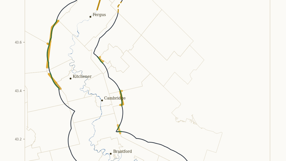
[Map of the Haldimand Tract — insert image here. Print caption: “The watercourse we measured from is the one in the Grand River Conservation Authority’s own data. The arithmetic is ours. Every input underneath it is theirs.”]
On the other half of this page is a map of the tract. Six miles deep on each side of the Grand, from the mouth at Lake Erie to the source. Take a minute with it before you read on, because how it was made matters as much as what it shows.
We started with the Crown’s own printed text of the Proclamation, which is the version provable in a courtroom by producing a printed copy. We took the river itself as the instrument tells us to, the banks of the river commonly called the Grand, and we measured outward from those banks, six miles on each side, mouth to source. The watercourse we measured from is the one in the Grand River Conservation Authority’s own data. The arithmetic is ours. Every input underneath it is theirs.
That is worth saying twice. To draw this map we did not need a single Indigenous source. No oral history, no traditional use study, nothing a Crown lawyer could call unreliable without calling his own province unreliable first. It is Ontario’s watercourse data and the Crown’s printed words, put together with grade-school geometry. If there is an error on that page, it came from them.
Which brings me to a question put in a Toronto courtroom this month.
In its opening at the Haldimand trial, Canada told the court that the Proclamation of 1784 was not a treaty and had failed to specify the layout of the grant with maps or surveys. A week later Crown lawyers were telling the same court that the Lands and Resources maps were not reliable. And somewhere in between, a Crown lawyer asked Phil Monture whether he was a cartographer.
There is no map that satisfies all three. They want a survey where the document has none, they call the surveys unreliable when they appear, and when the man who spent forty years assembling the parcel record walks in, the question is not whether his work is accurate but whether he was allowed to do it. Nobody said a parcel was wrong. Nobody said a date was wrong. The objection is to the man, offered in place of an answer to the work.
In June the Prime Minister put out a statement saying that thousands of years before any European arrived, Indigenous Peoples mapped this continent. He is closer to the truth than his government can afford. In 1801 a Blackfoot leader named Ac ko mok ki drew Peter Fidler a map of some two hundred thousand square miles, and a London printer stripped the attribution off it. Seventy years earlier Ochagach drew La Vérendrye the canoe route west, and that route became the fur trade’s highway. Neither man was a cartographer. The Crown’s charts were built out of their work.

Now look at the page again, because two things on it are worth your time.
The first is the shape. Follow the actual river, bend for bend, instead of the tidy schematic everyone has seen for fifty years, and the tract changes. Not dramatically, but it changes, and it changes in places where people live. A river is not a ruler. The 1784 instrument measured from a thing that meanders, which means the honest version of this boundary has the river’s shape in it, and most published versions do not.
The second is harder. On this drawing, a portion of the Six Nations reserve and most of the New Credit reserve fall outside the tract. The reserve is split. A large part of it sits inside the six-mile line and a smaller part sits beyond it. I am not going to pretend to know everything that follows from that, and anyone who tells you they do is guessing. But it is on the page, it came out of Ontario’s own data, and it is the sort of thing that ought to have been drawn and published a century ago.
Let me be plain about what this map is not.
It is not evidence that we were here first, and it is not offered as that. Our interest does not come from being here first. It comes from a document written in 1784 in the Crown’s own hand, naming a people and saying their posterity were to enjoy that land for ever. A court reads that kind of holding within the four corners of the paper. An instrument does not need a survey attached to say what it says. Six miles deep from each side of the river, from Lake Erie to the head of the said river, is already a description. A surveyor could walk it tomorrow. That is precisely what we did on paper.
So the complaint about maps and surveys deserves one more look. The Crown is not saying the words are unclear. It is saying the words are insufficient, which is a different thing and a convenient one, because the party that never surveyed the grant in two hundred and forty-two years is the same party now objecting that nobody surveyed it.
To the government of Canada: you asked for a map. It is printed here, at the size a newspaper allows, drawn from your own river data and your own printed words. You will find it easier to read than the one you have been avoiding, which is the register of your own transactions on the same land.
Originally published in the Two Row Times, October 21, 2026 (Volume 14, Issue 10), page 6.